


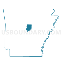
Matthews Voting District, Faulkner County, Arkansas
About
Outline

Summary
| Unique Area Identifier | 526450 |
| Name | Matthews Voting District |
| County | Faulkner County |
| State | Arkansas |
| Area (square miles) | 21.77 |
| Land Area (square miles) | 21.77 |
| Water Area (square miles) | 0.00 |
| % of Land Area | 100.00 |
| % of Water Area | 0.00 |
| Latitude of the Internal Point | 35.24349740 |
| Longtitude of the Internal Point | -92.27054410 |
Maps


Graphs
Select a template below for downloading or customizing gragh for Matthews Voting District, Faulkner County, Arkansas


Neighbors
Neighoring Voting District (by Name) Neighboring Voting District on the Map
- Benton Voting District, Faulkner County, AR
- California Voting District, Faulkner County, AR
- Enola Voting District, Faulkner County, AR
- Hardin Rural Voting District, Faulkner County, AR
- Harve Voting District, Faulkner County, AR
Top 10 Neighboring County Subdivision (by Population) Neighboring County Subdivision on the Map
- Hardin township, Faulkner County, AR (6,775)
- California township, Faulkner County, AR (2,089)
- Harve township, Faulkner County, AR (1,050)
- Benton township, Faulkner County, AR (961)
- Enola township, Faulkner County, AR (855)
- Matthews township, Faulkner County, AR (591)
Top 10 Neighboring Place (by Population) Neighboring Place on the Map
Top 10 Neighboring Unified School District (by Population) Neighboring Unified School District on the Map
- Greenbrier School District, AR (15,028)
- Quitman School District, AR (4,926)
- Mount Vernon-Enola School District, AR (2,964)
- Guy-Perkins Schools, AR (2,521)